
Product Comparison
Select up to 4 products to compare specs, features, and pricing side by side.

4DRC F15 Professional Drone with EIS 3-axis Gimbal Camera
A19P Pro Carbon Fiber Brushless Motor 4k Camera Drone
A21 PRO Mechanical Armor Style WiFi FPV
Aerobat HC702 Rc Pocket Drone
Aluminum Alloy Motor Cover DJI Mini 2Mini SE/Mini 3/Mini 3Pro/Mini 4 Pro
Beta FPV Aquila16 FPV Drone
CXF22 Brushless Motor Drone 2025
D12 Drone 4k Camera with 3 axis Gimbal
D22 Drone with LCD Screen Remote 2025
DJI 100W USB-C Power Adapter
DJI Action 6 Adventure Combo
DJI Agras T25 (Call For Deal)
DJI Agras T50 (Call for Deal)
DJI Air 2S Fly More Combo with 5.4k Video
DJI Air 3 Drone Fly More Combo with RC 2 Controller
DJI AIR 3 FLY MORE COMBO (DJI RC-N2)
DJI Air 3S Fly More Combo DJI RC 2
DJI Air 3S Fly More Combo (DJI RC-N3)
DJI Authorised 65W Portable Charger
DJI Avata 2 Fly More Combo
DJI D-RTK 3 Multifunctional Station
DJI Flip 6-Pack Filters Set (CPL/ ND16/32/64/128/UV)
DJI Flip Drone with RC-N3 Standard Edition
DJI Flip Fly More Combo With DJI RC 2
DJI Matrice 30T Worry-Free Plus Combo
DJI Matrice 350 RTK Industrial Drone
DJI Matrice 400 Worry-Free Plus Combo (Call For Deal)
DJI Matrice 4E Enterprise RTK Drone
DJI Matrice 4T Thermal Drone
DJI Mavic 3 Classic (DJI RC 2)
DJI Mavic 3 Fly More Combo Drone with N2 RC
DJI Mavic 3 Fly More Kit for DJI Mavic 3/Mavic 3 Classic/Mavic 3 Pro Accessories Combo
DJI Mavic 3 Pro with DJI RC 2
DJI Mavic 4 Pro Creator Combo With RC Pro 2
DJI Mavic 4 Pro Fly More Combo with dji rc 2
DJI Mavic Mini Fly More Combo
Dji Mavic Mini/Mini 2/Mini 2 SE propellers
DJI Mic 2 Dual Microphone Combo
DJI Mic 2 Standard Set (1 TX + 1 RX) For Single User
DJI Mic 2 Transmitter Wireless Microphone
DJI Mic 3 (1Tx+1Rx)
DJI Mic 3 (2 TX + 1 RX + Charging Case)
DJI Mic Mini (1 TX + 1 RX) Wireless Microphone for Single User
DJI Mic Mini (2 TX + 1 RX + Charging Case)
DJI Mic Mini Transmitter
DJI Mini 2 SE Fly More Combo
DJI Mini 2 SE Standard Edition
DJI mini 2SE Landing Gear
DJI Mini 2SE Propeller Guard
DJI Mini 3 ( DJI RC-N1 ) + Fly More Combo
DJI Mini 3 Fly More Combo (DJI RC)
DJI Mini 3 Pro Fly More Kit Plus
DJI Mini 3 Pro with DJI RC (Remote Controller)
DJI Mini 3 Pro with N1 RC Drone – Ultimate Aerial Photography Experience
DJI Mini 3 pro/Mini 4 pro Silicone Case
DJI Mini 3 Series ND Filter Set (ND16/64/256)
DJI Mini 3/Mini 3pro/Mini 2SE N1 Rc Silicone Case
DJI Mini 4 Pro Camera Lens 6-pack Filters Set
DJI Mini 4 Pro Fly More Combo Plus with RC 2 Controller
DJI Mini 4 Pro Landing Gear
DJI Mini 4 Pro Landing Gear
DJI Mini 4 Pro ND Filter
DJi Mini 4 pro propeller Guard
Dji Mini 4 pro Propellers
DJI Mini 4K Drone With RC-N1 Controller
DJI Mini 4K Fly More Combo
DJI Mini 5 Pro Drone with RC-N3 controller
DJI Mini 5 Pro Fly More Combo
DJI Mini 5 Pro Fly More Combo Plus
DJI Neo 2 Fly More Combo
DJI Neo 2 Fly More Combo (Only Drone)
DJI Neo 2 Motion Fly More Combo
DJI Neo 2 Standard Pack
DJI Neo Bag- Portable Storage Protective Bag
DJI Neo Battery
DJI Neo Drone Standard Edition 2025
DJI Neo Fly More Combo Pack
Dji Neo Fly More Combo with Neo Bag
Dji Neo Gimbal Bumper Guard
DJI Neo Motion Fly More Combo Drone
Dji Neo Propeller Guard Bumper
DJI Orginal Carry Bag for Mini Series
Dji Osmo 360 Adventure Combo
DJI Osmo Action 5 Pro Standard Combo
DJI Osmo Mobile 7
Dji Osmo Mobile 7P
DJI Osmo Mobile 8 Handheld Gimbal
DJI Osmo Mobile SE
DJI Osmo Nano 128 GB
Dji Osmo Pocket 3 Glass protector
DJI RC 2 Remote Control Case
Dji RC Protector Glass
DJI RC-N3/ N2/ N1 STARTRC Silicone Protector(Gray)
DJI RC/DJI RC 2/DJI RC Pro Lanyard STARTRC
DJI RC/RC 2 Screen Protector
DJI RS 4 Gimbal Stabilizer
DJI RS 4 Mini Gimbal Stabilizer
DJI RS 5 Standard Pack
Dji Zenmuse H30T Worry-Free Basic Combo
DJI Zenmuse L2 Worry-Free Basic Combo
DJI Zenmuse P1 Worry-Free Basic Combo
DJW M4 Ultra 4k Camera with Display Remote Drone 2025
Drone Landing Pad Pro STARTRC
E69 Mini RC Drone
E88 Evo Brushless HD Camera Drone
E88 Max Brushless HD Camera Drone
E88 Pro Max Drone Brushless Motor with 4K Camera Toy
E88/E99 HD Camera Drone
E88D Drone Rc Remote and lighting Effect HD Drone
E88S Rc Drone HD Camera Obstacle avoider Brushless Motor Drone
E99 Air Mini Display Remote Drone
E99 Max Brushless Motor Drone
E99 Mini Display Remote Drone 2025
Es105 Max Gps Drone
ES105 Max Gps with Big Display Remote
F11 s 4k Pro/ plus Spare Battery
F88 Evo Brushless Motor 4k camera Drone
F88 Max HD Camera Drone
FLH X5HW Drone Dual Camera with Dual Battery
FLYX MAX 2
GT50 RC Screen Drone
H20 Max Drone HD Camera
H21 VR Drone 4K Dual Camera with VR Glasses
H23 GPS Foldable Toy Drone 2024
H26 Drone With Brushless Motor HD Camera
i1 Pro Drone Mini 2025
i5 Pro Beginner Drone 2025
JS39P HD Camera Drone with Display Remote
K3 E99 Pro FPV 4K Dual Camera Toy Drone
K3 Max Drone with Avoidence Sensor
K3 Max Gps Drone
K811 MAX Mini 4K HD GPS Drone
L600 PRO MAX GPS Drone
Landing Pad For Drone (Round Shape) 80cm
M101 Max Gps Drone 2025
M101 Plus 3 Axis Gimbal 4K Camera Drone
M108 Plus 3-Axis Gimbal 4K Camera 8km Long Range Drone 2025
M33 Max Drone 4K HD Camera Obstacle Avoidance Aerial
M33 Max Drone 4K HD Camera RC Remote
M66 Fold Smart RC Drone 2025
ND Filter For DJI Mini 4K / Mini 2 SE / Mini 2 (ND8 / 16 / 32 / 64 )
ND Filters for DJI NEO
New S119 Drone with Remote Display 4k Camera
Osmo Action 4 Adventure Combo
Osmo Action 5 Pro Adventure Combo
Osmo Pocket 3 Creator Combo
Propeller Guard For Dji Mini 2/Mini 4k/Mini 2 Se/Mavic Mini
R36S Retro Handheld Gaming Console
Robot Dog with AI RC Control Educational Toy
S107 Max with RC Display Remote Drone 2025
S156 Beginner Drone FPV HD Camera Brushless Motor 2025
S159 Drone 5G WIFI GPS FPV Drone
S28 Gps Drone
Sandisk Extreme Pro 128GB 200mbps MicroSDXC UHS-1 Memory Card With Adapter
Sandisk Extreme PRO 256GB 200mbps MicroSDXC UHS-I Memory Card With Adapter
Sandisk Extreme PRO 512GB 200mbps MicroSDXC UHS-1 Memory Card With Adapter
SG109 MAX 2 4K GPS Drone Professional 3-Axis Gimbal
Sg109 Max Gps 4K Camera Drone 2025
SG109 Pro With Remote Display 2025
Silicone Case For DJI OSMO Pocket 3
Silicone Protective Case for DJI RC 2 Remote Controller
SJRC F11/F11s 4k pro Propellers
SJRC F11/F11s/F11 s 4k pro Arm with propellers
SJRC F11s 4K Pro+ Combo 2025
SJRC F22 S2 Pro+ 4K 2024
SJRC F22 S3 XR Drone with 6K Camera 2025
SJRC F7/F7s 4k pro Propellers
SJRC F7s 4k Pro 3 axis gimble 4k Camera
SJRC F7s 4k Pro 3 axis gimble 4k Camera With Sensor
SMRC P7 MAX 8k Camera Drone 2025
STARTRC Hard Carrying Case for DJI Mini 5 Pro Fly More Combo
SX1 Drone GPS Drone 4K Profesional 3-Axis Gimbal
V06 Gps Drone with 3 axis Gimbal
V168 Pro Max Gps Drone 8k Camera HD Professional 5g Wifi
V196 PRO Brushless Drone HD Dual Camera
V198 Gps Drone with Big Display Remote 8k camera
V198 Laser 8K 5G Brushless Drone With GPS Obstacle Avoidance
V600 Drone 4k HD Camera 2025
V666 4K Camera Brushless Motor Drone 2025
XiL 017 Drone 10KM Range with 3 axis Gimbal
XJ2 Mini Drone with Dual HD FPV Camera
Z908 MAX with Brushless Motor 2025
Zenmuse H30 Worry-Free Basic Combo
DJI Accessories
৳9,699
Details
4DRC F15 Professional Drone with EIS 3-axis Gimbal Camera
A19P Pro Carbon Fiber Brushless Motor 4k Camera Drone
A21 PRO Mechanical Armor Style WiFi FPV
Aerobat HC702 Rc Pocket Drone
Aluminum Alloy Motor Cover DJI Mini 2Mini SE/Mini 3/Mini 3Pro/Mini 4 Pro
Beta FPV Aquila16 FPV Drone
CXF22 Brushless Motor Drone 2025
D12 Drone 4k Camera with 3 axis Gimbal
D22 Drone with LCD Screen Remote 2025
DJI 100W USB-C Power Adapter
DJI Action 6 Adventure Combo
DJI Agras T25 (Call For Deal)
DJI Agras T50 (Call for Deal)
DJI Air 2S Fly More Combo with 5.4k Video
DJI Air 3 Drone Fly More Combo with RC 2 Controller
DJI AIR 3 FLY MORE COMBO (DJI RC-N2)
DJI Air 3S Fly More Combo DJI RC 2
DJI Air 3S Fly More Combo (DJI RC-N3)
DJI Authorised 65W Portable Charger
DJI Avata 2 Fly More Combo
DJI D-RTK 3 Multifunctional Station
DJI Flip 6-Pack Filters Set (CPL/ ND16/32/64/128/UV)
DJI Flip Drone with RC-N3 Standard Edition
DJI Flip Fly More Combo With DJI RC 2
DJI Matrice 30T Worry-Free Plus Combo
DJI Matrice 350 RTK Industrial Drone
DJI Matrice 400 Worry-Free Plus Combo (Call For Deal)
DJI Matrice 4E Enterprise RTK Drone
DJI Matrice 4T Thermal Drone
DJI Mavic 3 Classic (DJI RC 2)
DJI Mavic 3 Fly More Combo Drone with N2 RC
DJI Mavic 3 Fly More Kit for DJI Mavic 3/Mavic 3 Classic/Mavic 3 Pro Accessories Combo
DJI Mavic 3 Pro with DJI RC 2
DJI Mavic 4 Pro Creator Combo With RC Pro 2
DJI Mavic 4 Pro Fly More Combo with dji rc 2
DJI Mavic Mini Fly More Combo
Dji Mavic Mini/Mini 2/Mini 2 SE propellers
DJI Mic 2 Dual Microphone Combo
DJI Mic 2 Standard Set (1 TX + 1 RX) For Single User
DJI Mic 2 Transmitter Wireless Microphone
DJI Mic 3 (1Tx+1Rx)
DJI Mic 3 (2 TX + 1 RX + Charging Case)
DJI Mic Mini (1 TX + 1 RX) Wireless Microphone for Single User
DJI Mic Mini (2 TX + 1 RX + Charging Case)
DJI Mic Mini Transmitter
DJI Mini 2 SE Fly More Combo
DJI Mini 2 SE Standard Edition
DJI mini 2SE Landing Gear
DJI Mini 2SE Propeller Guard
DJI Mini 3 ( DJI RC-N1 ) + Fly More Combo
DJI Mini 3 Fly More Combo (DJI RC)
DJI Mini 3 Pro Fly More Kit Plus
DJI Mini 3 Pro with DJI RC (Remote Controller)
DJI Mini 3 Pro with N1 RC Drone – Ultimate Aerial Photography Experience
DJI Mini 3 pro/Mini 4 pro Silicone Case
DJI Mini 3 Series ND Filter Set (ND16/64/256)
DJI Mini 3/Mini 3pro/Mini 2SE N1 Rc Silicone Case
DJI Mini 4 Pro Camera Lens 6-pack Filters Set
DJI Mini 4 Pro Fly More Combo Plus with RC 2 Controller
DJI Mini 4 Pro Landing Gear
DJI Mini 4 Pro Landing Gear
DJI Mini 4 Pro ND Filter
DJi Mini 4 pro propeller Guard
Dji Mini 4 pro Propellers
DJI Mini 4K Drone With RC-N1 Controller
DJI Mini 4K Fly More Combo
DJI Mini 5 Pro Drone with RC-N3 controller
DJI Mini 5 Pro Fly More Combo
DJI Mini 5 Pro Fly More Combo Plus
DJI Neo 2 Fly More Combo
DJI Neo 2 Fly More Combo (Only Drone)
DJI Neo 2 Motion Fly More Combo
DJI Neo 2 Standard Pack
DJI Neo Bag- Portable Storage Protective Bag
DJI Neo Battery
DJI Neo Drone Standard Edition 2025
DJI Neo Fly More Combo Pack
Dji Neo Fly More Combo with Neo Bag
Dji Neo Gimbal Bumper Guard
DJI Neo Motion Fly More Combo Drone
Dji Neo Propeller Guard Bumper
DJI Orginal Carry Bag for Mini Series
Dji Osmo 360 Adventure Combo
DJI Osmo Action 5 Pro Standard Combo
DJI Osmo Mobile 7
Dji Osmo Mobile 7P
DJI Osmo Mobile 8 Handheld Gimbal
DJI Osmo Mobile SE
DJI Osmo Nano 128 GB
Dji Osmo Pocket 3 Glass protector
DJI RC 2 Remote Control Case
Dji RC Protector Glass
DJI RC-N3/ N2/ N1 STARTRC Silicone Protector(Gray)
DJI RC/DJI RC 2/DJI RC Pro Lanyard STARTRC
DJI RC/RC 2 Screen Protector
DJI RS 4 Gimbal Stabilizer
DJI RS 4 Mini Gimbal Stabilizer
DJI RS 5 Standard Pack
Dji Zenmuse H30T Worry-Free Basic Combo
DJI Zenmuse L2 Worry-Free Basic Combo
DJI Zenmuse P1 Worry-Free Basic Combo
DJW M4 Ultra 4k Camera with Display Remote Drone 2025
Drone Landing Pad Pro STARTRC
E69 Mini RC Drone
E88 Evo Brushless HD Camera Drone
E88 Max Brushless HD Camera Drone
E88 Pro Max Drone Brushless Motor with 4K Camera Toy
E88/E99 HD Camera Drone
E88D Drone Rc Remote and lighting Effect HD Drone
E88S Rc Drone HD Camera Obstacle avoider Brushless Motor Drone
E99 Air Mini Display Remote Drone
E99 Max Brushless Motor Drone
E99 Mini Display Remote Drone 2025
Es105 Max Gps Drone
ES105 Max Gps with Big Display Remote
F11 s 4k Pro/ plus Spare Battery
F88 Evo Brushless Motor 4k camera Drone
F88 Max HD Camera Drone
FLH X5HW Drone Dual Camera with Dual Battery
FLYX MAX 2
GT50 RC Screen Drone
H20 Max Drone HD Camera
H21 VR Drone 4K Dual Camera with VR Glasses
H23 GPS Foldable Toy Drone 2024
H26 Drone With Brushless Motor HD Camera
i1 Pro Drone Mini 2025
i5 Pro Beginner Drone 2025
JS39P HD Camera Drone with Display Remote
K3 E99 Pro FPV 4K Dual Camera Toy Drone
K3 Max Drone with Avoidence Sensor
K3 Max Gps Drone
K811 MAX Mini 4K HD GPS Drone
L600 PRO MAX GPS Drone
Landing Pad For Drone (Round Shape) 80cm
M101 Max Gps Drone 2025
M101 Plus 3 Axis Gimbal 4K Camera Drone
M108 Plus 3-Axis Gimbal 4K Camera 8km Long Range Drone 2025
M33 Max Drone 4K HD Camera Obstacle Avoidance Aerial
M33 Max Drone 4K HD Camera RC Remote
M66 Fold Smart RC Drone 2025
ND Filter For DJI Mini 4K / Mini 2 SE / Mini 2 (ND8 / 16 / 32 / 64 )
ND Filters for DJI NEO
New S119 Drone with Remote Display 4k Camera
Osmo Action 4 Adventure Combo
Osmo Action 5 Pro Adventure Combo
Osmo Pocket 3 Creator Combo
Propeller Guard For Dji Mini 2/Mini 4k/Mini 2 Se/Mavic Mini
R36S Retro Handheld Gaming Console
Robot Dog with AI RC Control Educational Toy
S107 Max with RC Display Remote Drone 2025
S156 Beginner Drone FPV HD Camera Brushless Motor 2025
S159 Drone 5G WIFI GPS FPV Drone
S28 Gps Drone
Sandisk Extreme Pro 128GB 200mbps MicroSDXC UHS-1 Memory Card With Adapter
Sandisk Extreme PRO 256GB 200mbps MicroSDXC UHS-I Memory Card With Adapter
Sandisk Extreme PRO 512GB 200mbps MicroSDXC UHS-1 Memory Card With Adapter
SG109 MAX 2 4K GPS Drone Professional 3-Axis Gimbal
Sg109 Max Gps 4K Camera Drone 2025
SG109 Pro With Remote Display 2025
Silicone Case For DJI OSMO Pocket 3
Silicone Protective Case for DJI RC 2 Remote Controller
SJRC F11/F11s 4k pro Propellers
SJRC F11/F11s/F11 s 4k pro Arm with propellers
SJRC F11s 4K Pro+ Combo 2025
SJRC F22 S2 Pro+ 4K 2024
SJRC F22 S3 XR Drone with 6K Camera 2025
SJRC F7/F7s 4k pro Propellers
SJRC F7s 4k Pro 3 axis gimble 4k Camera
SJRC F7s 4k Pro 3 axis gimble 4k Camera With Sensor
SMRC P7 MAX 8k Camera Drone 2025
STARTRC Hard Carrying Case for DJI Mini 5 Pro Fly More Combo
SX1 Drone GPS Drone 4K Profesional 3-Axis Gimbal
V06 Gps Drone with 3 axis Gimbal
V168 Pro Max Gps Drone 8k Camera HD Professional 5g Wifi
V196 PRO Brushless Drone HD Dual Camera
V198 Gps Drone with Big Display Remote 8k camera
V198 Laser 8K 5G Brushless Drone With GPS Obstacle Avoidance
V600 Drone 4k HD Camera 2025
V666 4K Camera Brushless Motor Drone 2025
XiL 017 Drone 10KM Range with 3 axis Gimbal
XJ2 Mini Drone with Dual HD FPV Camera
Z908 MAX with Brushless Motor 2025
Zenmuse H30 Worry-Free Basic Combo
DJI Industrial Series
৳0
Details
4DRC F15 Professional Drone with EIS 3-axis Gimbal Camera
A19P Pro Carbon Fiber Brushless Motor 4k Camera Drone
A21 PRO Mechanical Armor Style WiFi FPV
Aerobat HC702 Rc Pocket Drone
Aluminum Alloy Motor Cover DJI Mini 2Mini SE/Mini 3/Mini 3Pro/Mini 4 Pro
Beta FPV Aquila16 FPV Drone
CXF22 Brushless Motor Drone 2025
D12 Drone 4k Camera with 3 axis Gimbal
D22 Drone with LCD Screen Remote 2025
DJI 100W USB-C Power Adapter
DJI Action 6 Adventure Combo
DJI Agras T25 (Call For Deal)
DJI Agras T50 (Call for Deal)
DJI Air 2S Fly More Combo with 5.4k Video
DJI Air 3 Drone Fly More Combo with RC 2 Controller
DJI AIR 3 FLY MORE COMBO (DJI RC-N2)
DJI Air 3S Fly More Combo DJI RC 2
DJI Air 3S Fly More Combo (DJI RC-N3)
DJI Authorised 65W Portable Charger
DJI Avata 2 Fly More Combo
DJI D-RTK 3 Multifunctional Station
DJI Flip 6-Pack Filters Set (CPL/ ND16/32/64/128/UV)
DJI Flip Drone with RC-N3 Standard Edition
DJI Flip Fly More Combo With DJI RC 2
DJI Matrice 30T Worry-Free Plus Combo
DJI Matrice 350 RTK Industrial Drone
DJI Matrice 400 Worry-Free Plus Combo (Call For Deal)
DJI Matrice 4E Enterprise RTK Drone
DJI Matrice 4T Thermal Drone
DJI Mavic 3 Classic (DJI RC 2)
DJI Mavic 3 Fly More Combo Drone with N2 RC
DJI Mavic 3 Fly More Kit for DJI Mavic 3/Mavic 3 Classic/Mavic 3 Pro Accessories Combo
DJI Mavic 3 Pro with DJI RC 2
DJI Mavic 4 Pro Creator Combo With RC Pro 2
DJI Mavic 4 Pro Fly More Combo with dji rc 2
DJI Mavic Mini Fly More Combo
Dji Mavic Mini/Mini 2/Mini 2 SE propellers
DJI Mic 2 Dual Microphone Combo
DJI Mic 2 Standard Set (1 TX + 1 RX) For Single User
DJI Mic 2 Transmitter Wireless Microphone
DJI Mic 3 (1Tx+1Rx)
DJI Mic 3 (2 TX + 1 RX + Charging Case)
DJI Mic Mini (1 TX + 1 RX) Wireless Microphone for Single User
DJI Mic Mini (2 TX + 1 RX + Charging Case)
DJI Mic Mini Transmitter
DJI Mini 2 SE Fly More Combo
DJI Mini 2 SE Standard Edition
DJI mini 2SE Landing Gear
DJI Mini 2SE Propeller Guard
DJI Mini 3 ( DJI RC-N1 ) + Fly More Combo
DJI Mini 3 Fly More Combo (DJI RC)
DJI Mini 3 Pro Fly More Kit Plus
DJI Mini 3 Pro with DJI RC (Remote Controller)
DJI Mini 3 Pro with N1 RC Drone – Ultimate Aerial Photography Experience
DJI Mini 3 pro/Mini 4 pro Silicone Case
DJI Mini 3 Series ND Filter Set (ND16/64/256)
DJI Mini 3/Mini 3pro/Mini 2SE N1 Rc Silicone Case
DJI Mini 4 Pro Camera Lens 6-pack Filters Set
DJI Mini 4 Pro Fly More Combo Plus with RC 2 Controller
DJI Mini 4 Pro Landing Gear
DJI Mini 4 Pro Landing Gear
DJI Mini 4 Pro ND Filter
DJi Mini 4 pro propeller Guard
Dji Mini 4 pro Propellers
DJI Mini 4K Drone With RC-N1 Controller
DJI Mini 4K Fly More Combo
DJI Mini 5 Pro Drone with RC-N3 controller
DJI Mini 5 Pro Fly More Combo
DJI Mini 5 Pro Fly More Combo Plus
DJI Neo 2 Fly More Combo
DJI Neo 2 Fly More Combo (Only Drone)
DJI Neo 2 Motion Fly More Combo
DJI Neo 2 Standard Pack
DJI Neo Bag- Portable Storage Protective Bag
DJI Neo Battery
DJI Neo Drone Standard Edition 2025
DJI Neo Fly More Combo Pack
Dji Neo Fly More Combo with Neo Bag
Dji Neo Gimbal Bumper Guard
DJI Neo Motion Fly More Combo Drone
Dji Neo Propeller Guard Bumper
DJI Orginal Carry Bag for Mini Series
Dji Osmo 360 Adventure Combo
DJI Osmo Action 5 Pro Standard Combo
DJI Osmo Mobile 7
Dji Osmo Mobile 7P
DJI Osmo Mobile 8 Handheld Gimbal
DJI Osmo Mobile SE
DJI Osmo Nano 128 GB
Dji Osmo Pocket 3 Glass protector
DJI RC 2 Remote Control Case
Dji RC Protector Glass
DJI RC-N3/ N2/ N1 STARTRC Silicone Protector(Gray)
DJI RC/DJI RC 2/DJI RC Pro Lanyard STARTRC
DJI RC/RC 2 Screen Protector
DJI RS 4 Gimbal Stabilizer
DJI RS 4 Mini Gimbal Stabilizer
DJI RS 5 Standard Pack
Dji Zenmuse H30T Worry-Free Basic Combo
DJI Zenmuse L2 Worry-Free Basic Combo
DJI Zenmuse P1 Worry-Free Basic Combo
DJW M4 Ultra 4k Camera with Display Remote Drone 2025
Drone Landing Pad Pro STARTRC
E69 Mini RC Drone
E88 Evo Brushless HD Camera Drone
E88 Max Brushless HD Camera Drone
E88 Pro Max Drone Brushless Motor with 4K Camera Toy
E88/E99 HD Camera Drone
E88D Drone Rc Remote and lighting Effect HD Drone
E88S Rc Drone HD Camera Obstacle avoider Brushless Motor Drone
E99 Air Mini Display Remote Drone
E99 Max Brushless Motor Drone
E99 Mini Display Remote Drone 2025
Es105 Max Gps Drone
ES105 Max Gps with Big Display Remote
F11 s 4k Pro/ plus Spare Battery
F88 Evo Brushless Motor 4k camera Drone
F88 Max HD Camera Drone
FLH X5HW Drone Dual Camera with Dual Battery
FLYX MAX 2
GT50 RC Screen Drone
H20 Max Drone HD Camera
H21 VR Drone 4K Dual Camera with VR Glasses
H23 GPS Foldable Toy Drone 2024
H26 Drone With Brushless Motor HD Camera
i1 Pro Drone Mini 2025
i5 Pro Beginner Drone 2025
JS39P HD Camera Drone with Display Remote
K3 E99 Pro FPV 4K Dual Camera Toy Drone
K3 Max Drone with Avoidence Sensor
K3 Max Gps Drone
K811 MAX Mini 4K HD GPS Drone
L600 PRO MAX GPS Drone
Landing Pad For Drone (Round Shape) 80cm
M101 Max Gps Drone 2025
M101 Plus 3 Axis Gimbal 4K Camera Drone
M108 Plus 3-Axis Gimbal 4K Camera 8km Long Range Drone 2025
M33 Max Drone 4K HD Camera Obstacle Avoidance Aerial
M33 Max Drone 4K HD Camera RC Remote
M66 Fold Smart RC Drone 2025
ND Filter For DJI Mini 4K / Mini 2 SE / Mini 2 (ND8 / 16 / 32 / 64 )
ND Filters for DJI NEO
New S119 Drone with Remote Display 4k Camera
Osmo Action 4 Adventure Combo
Osmo Action 5 Pro Adventure Combo
Osmo Pocket 3 Creator Combo
Propeller Guard For Dji Mini 2/Mini 4k/Mini 2 Se/Mavic Mini
R36S Retro Handheld Gaming Console
Robot Dog with AI RC Control Educational Toy
S107 Max with RC Display Remote Drone 2025
S156 Beginner Drone FPV HD Camera Brushless Motor 2025
S159 Drone 5G WIFI GPS FPV Drone
S28 Gps Drone
Sandisk Extreme Pro 128GB 200mbps MicroSDXC UHS-1 Memory Card With Adapter
Sandisk Extreme PRO 256GB 200mbps MicroSDXC UHS-I Memory Card With Adapter
Sandisk Extreme PRO 512GB 200mbps MicroSDXC UHS-1 Memory Card With Adapter
SG109 MAX 2 4K GPS Drone Professional 3-Axis Gimbal
Sg109 Max Gps 4K Camera Drone 2025
SG109 Pro With Remote Display 2025
Silicone Case For DJI OSMO Pocket 3
Silicone Protective Case for DJI RC 2 Remote Controller
SJRC F11/F11s 4k pro Propellers
SJRC F11/F11s/F11 s 4k pro Arm with propellers
SJRC F11s 4K Pro+ Combo 2025
SJRC F22 S2 Pro+ 4K 2024
SJRC F22 S3 XR Drone with 6K Camera 2025
SJRC F7/F7s 4k pro Propellers
SJRC F7s 4k Pro 3 axis gimble 4k Camera
SJRC F7s 4k Pro 3 axis gimble 4k Camera With Sensor
SMRC P7 MAX 8k Camera Drone 2025
STARTRC Hard Carrying Case for DJI Mini 5 Pro Fly More Combo
SX1 Drone GPS Drone 4K Profesional 3-Axis Gimbal
V06 Gps Drone with 3 axis Gimbal
V168 Pro Max Gps Drone 8k Camera HD Professional 5g Wifi
V196 PRO Brushless Drone HD Dual Camera
V198 Gps Drone with Big Display Remote 8k camera
V198 Laser 8K 5G Brushless Drone With GPS Obstacle Avoidance
V600 Drone 4k HD Camera 2025
V666 4K Camera Brushless Motor Drone 2025
XiL 017 Drone 10KM Range with 3 axis Gimbal
XJ2 Mini Drone with Dual HD FPV Camera
Z908 MAX with Brushless Motor 2025
Zenmuse H30 Worry-Free Basic Combo
DJI Accessories
৳4,500
Details
Add Product
4DRC F15 Professional Drone with EIS 3-axis Gimbal Camera
A19P Pro Carbon Fiber Brushless Motor 4k Camera Drone
A21 PRO Mechanical Armor Style WiFi FPV
Aerobat HC702 Rc Pocket Drone
Aluminum Alloy Motor Cover DJI Mini 2Mini SE/Mini 3/Mini 3Pro/Mini 4 Pro
Beta FPV Aquila16 FPV Drone
CXF22 Brushless Motor Drone 2025
D12 Drone 4k Camera with 3 axis Gimbal
D22 Drone with LCD Screen Remote 2025
DJI 100W USB-C Power Adapter
DJI Action 6 Adventure Combo
DJI Agras T25 (Call For Deal)
DJI Agras T50 (Call for Deal)
DJI Air 2S Fly More Combo with 5.4k Video
DJI Air 3 Drone Fly More Combo with RC 2 Controller
DJI AIR 3 FLY MORE COMBO (DJI RC-N2)
DJI Air 3S Fly More Combo DJI RC 2
DJI Air 3S Fly More Combo (DJI RC-N3)
DJI Authorised 65W Portable Charger
DJI Avata 2 Fly More Combo
DJI D-RTK 3 Multifunctional Station
DJI Flip 6-Pack Filters Set (CPL/ ND16/32/64/128/UV)
DJI Flip Drone with RC-N3 Standard Edition
DJI Flip Fly More Combo With DJI RC 2
DJI Matrice 30T Worry-Free Plus Combo
DJI Matrice 350 RTK Industrial Drone
DJI Matrice 4E Enterprise RTK Drone
DJI Matrice 4T Thermal Drone
DJI Mavic 3 Classic (DJI RC 2)
DJI Mavic 3 Fly More Combo Drone with N2 RC
DJI Mavic 3 Fly More Kit for DJI Mavic 3/Mavic 3 Classic/Mavic 3 Pro Accessories Combo
DJI Mavic 3 Pro with DJI RC 2
DJI Mavic 4 Pro Creator Combo With RC Pro 2
DJI Mavic 4 Pro Fly More Combo with dji rc 2
DJI Mavic Mini Fly More Combo
Dji Mavic Mini/Mini 2/Mini 2 SE propellers
DJI Mic 2 Dual Microphone Combo
DJI Mic 2 Standard Set (1 TX + 1 RX) For Single User
DJI Mic 2 Transmitter Wireless Microphone
DJI Mic 3 (1Tx+1Rx)
DJI Mic 3 (2 TX + 1 RX + Charging Case)
DJI Mic Mini (1 TX + 1 RX) Wireless Microphone for Single User
DJI Mic Mini (2 TX + 1 RX + Charging Case)
DJI Mic Mini Transmitter
DJI Mini 2 SE Fly More Combo
DJI Mini 2 SE Standard Edition
DJI mini 2SE Landing Gear
DJI Mini 2SE Propeller Guard
DJI Mini 3 ( DJI RC-N1 ) + Fly More Combo
DJI Mini 3 Fly More Combo (DJI RC)
DJI Mini 3 Pro Fly More Kit Plus
DJI Mini 3 Pro with DJI RC (Remote Controller)
DJI Mini 3 Pro with N1 RC Drone – Ultimate Aerial Photography Experience
DJI Mini 3 pro/Mini 4 pro Silicone Case
DJI Mini 3 Series ND Filter Set (ND16/64/256)
DJI Mini 3/Mini 3pro/Mini 2SE N1 Rc Silicone Case
DJI Mini 4 Pro Camera Lens 6-pack Filters Set
DJI Mini 4 Pro Fly More Combo Plus with RC 2 Controller
DJI Mini 4 Pro Landing Gear
DJI Mini 4 Pro Landing Gear
DJI Mini 4 Pro ND Filter
DJi Mini 4 pro propeller Guard
Dji Mini 4 pro Propellers
DJI Mini 4K Drone With RC-N1 Controller
DJI Mini 4K Fly More Combo
DJI Mini 5 Pro Drone with RC-N3 controller
DJI Mini 5 Pro Fly More Combo
DJI Mini 5 Pro Fly More Combo Plus
DJI Neo 2 Fly More Combo
DJI Neo 2 Fly More Combo (Only Drone)
DJI Neo 2 Motion Fly More Combo
DJI Neo 2 Standard Pack
DJI Neo Bag- Portable Storage Protective Bag
DJI Neo Battery
DJI Neo Drone Standard Edition 2025
DJI Neo Fly More Combo Pack
Dji Neo Fly More Combo with Neo Bag
Dji Neo Gimbal Bumper Guard
DJI Neo Motion Fly More Combo Drone
Dji Neo Propeller Guard Bumper
DJI Orginal Carry Bag for Mini Series
Dji Osmo 360 Adventure Combo
DJI Osmo Action 5 Pro Standard Combo
DJI Osmo Mobile 7
Dji Osmo Mobile 7P
DJI Osmo Mobile 8 Handheld Gimbal
DJI Osmo Mobile SE
DJI Osmo Nano 128 GB
Dji Osmo Pocket 3 Glass protector
DJI RC 2 Remote Control Case
Dji RC Protector Glass
DJI RC-N3/ N2/ N1 STARTRC Silicone Protector(Gray)
DJI RC/DJI RC 2/DJI RC Pro Lanyard STARTRC
DJI RC/RC 2 Screen Protector
DJI RS 4 Gimbal Stabilizer
DJI RS 4 Mini Gimbal Stabilizer
DJI RS 5 Standard Pack
Dji Zenmuse H30T Worry-Free Basic Combo
DJI Zenmuse L2 Worry-Free Basic Combo
DJI Zenmuse P1 Worry-Free Basic Combo
DJW M4 Ultra 4k Camera with Display Remote Drone 2025
Drone Landing Pad Pro STARTRC
E69 Mini RC Drone
E88 Evo Brushless HD Camera Drone
E88 Max Brushless HD Camera Drone
E88 Pro Max Drone Brushless Motor with 4K Camera Toy
E88/E99 HD Camera Drone
E88D Drone Rc Remote and lighting Effect HD Drone
E88S Rc Drone HD Camera Obstacle avoider Brushless Motor Drone
E99 Air Mini Display Remote Drone
E99 Max Brushless Motor Drone
E99 Mini Display Remote Drone 2025
Es105 Max Gps Drone
ES105 Max Gps with Big Display Remote
F11 s 4k Pro/ plus Spare Battery
F88 Evo Brushless Motor 4k camera Drone
F88 Max HD Camera Drone
FLH X5HW Drone Dual Camera with Dual Battery
FLYX MAX 2
GT50 RC Screen Drone
H20 Max Drone HD Camera
H21 VR Drone 4K Dual Camera with VR Glasses
H23 GPS Foldable Toy Drone 2024
H26 Drone With Brushless Motor HD Camera
i1 Pro Drone Mini 2025
i5 Pro Beginner Drone 2025
JS39P HD Camera Drone with Display Remote
K3 E99 Pro FPV 4K Dual Camera Toy Drone
K3 Max Drone with Avoidence Sensor
K3 Max Gps Drone
K811 MAX Mini 4K HD GPS Drone
L600 PRO MAX GPS Drone
Landing Pad For Drone (Round Shape) 80cm
M101 Max Gps Drone 2025
M101 Plus 3 Axis Gimbal 4K Camera Drone
M108 Plus 3-Axis Gimbal 4K Camera 8km Long Range Drone 2025
M33 Max Drone 4K HD Camera Obstacle Avoidance Aerial
M33 Max Drone 4K HD Camera RC Remote
M66 Fold Smart RC Drone 2025
ND Filter For DJI Mini 4K / Mini 2 SE / Mini 2 (ND8 / 16 / 32 / 64 )
ND Filters for DJI NEO
New S119 Drone with Remote Display 4k Camera
Osmo Action 4 Adventure Combo
Osmo Action 5 Pro Adventure Combo
Osmo Pocket 3 Creator Combo
Propeller Guard For Dji Mini 2/Mini 4k/Mini 2 Se/Mavic Mini
R36S Retro Handheld Gaming Console
Robot Dog with AI RC Control Educational Toy
S107 Max with RC Display Remote Drone 2025
S156 Beginner Drone FPV HD Camera Brushless Motor 2025
S159 Drone 5G WIFI GPS FPV Drone
S28 Gps Drone
Sandisk Extreme PRO 256GB 200mbps MicroSDXC UHS-I Memory Card With Adapter
SG109 MAX 2 4K GPS Drone Professional 3-Axis Gimbal
Sg109 Max Gps 4K Camera Drone 2025
SG109 Pro With Remote Display 2025
Silicone Case For DJI OSMO Pocket 3
Silicone Protective Case for DJI RC 2 Remote Controller
SJRC F11/F11s 4k pro Propellers
SJRC F11/F11s/F11 s 4k pro Arm with propellers
SJRC F11s 4K Pro+ Combo 2025
SJRC F22 S2 Pro+ 4K 2024
SJRC F22 S3 XR Drone with 6K Camera 2025
SJRC F7/F7s 4k pro Propellers
SJRC F7s 4k Pro 3 axis gimble 4k Camera
SJRC F7s 4k Pro 3 axis gimble 4k Camera With Sensor
SMRC P7 MAX 8k Camera Drone 2025
STARTRC Hard Carrying Case for DJI Mini 5 Pro Fly More Combo
SX1 Drone GPS Drone 4K Profesional 3-Axis Gimbal
V06 Gps Drone with 3 axis Gimbal
V168 Pro Max Gps Drone 8k Camera HD Professional 5g Wifi
V196 PRO Brushless Drone HD Dual Camera
V198 Gps Drone with Big Display Remote 8k camera
V198 Laser 8K 5G Brushless Drone With GPS Obstacle Avoidance
V600 Drone 4k HD Camera 2025
V666 4K Camera Brushless Motor Drone 2025
XiL 017 Drone 10KM Range with 3 axis Gimbal
XJ2 Mini Drone with Dual HD FPV Camera
Z908 MAX with Brushless Motor 2025
Zenmuse H30 Worry-Free Basic Combo
3 Products Selected
Overview
Price
৳9,699
৳0
৳4,500
Category
DJI Accessories
DJI Industrial Series
DJI Accessories
Stock Status
In stock
In stock
In stock
General
Capacity
512GB
20254 mAh
128GB
Flash Type
Flash memory
—
Flash memory
Read Speed
Up to 200MB/s
—
Up to 200MB/s
Write Speed
Up to 140MB/s
—
Up to 90MB/s
Dimension
10.92mm x 14.99mm x 1.02mm
—
10.92mm x 14.99mm x 1.02mm
Warranty
Lifetime Limited Warranty (Must Claim With Box & All Accessories)
—
Life Time
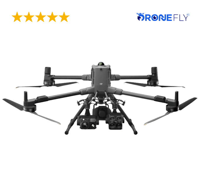
Takeoff Weight (with propellers)
—
Without Batteries: 5020±20 g
With Batteries: 9740±40 gThe actual product weight may vary due to differences in batch materials and external factors.
—
Max Takeoff Weight
—
15.8 kg
—
Dimensions
—
268×163×94.5 mm (L×W×H)
Width including external antenna folded, thickness including handle and controller sticks.
—
Max Payload
—
6 kg
The 6 kg payload is measured at the third gimbal connector under sea level conditions. Payload capacity decreases as altitude increases. For details, refer to the official user manual.
—
Propeller Size
—
25 inches
—
Diagonal Wheelbase
—
1070 mm
—
Max Ascent Speed
—
10 m/s
—
Max Descent Speed
—
8 m/s
—
Max Horizontal Speed (at sea level, no wind)
—
25 m/s
—
Max Takeoff Altitude
—
7000 m
—
Max Flight Time (no wind)
—
59 minutes
Measured with the aircraft flying forward at a constant speed of 10 m/s in a windless environment at sea level, carrying only the H30T (total weight 10,670 g), and from 100% battery level until 0%. Data is for reference only. Actual experience may vary depending on the environment, usage, and firmware version.
—
Max Hover Time (no wind)
—
53 minutes
Measured with the aircraft hovering in a windless environment at sea level, carrying only the H30T (total weight 10,670 g), and from 100% battery level until 0%. Data is for reference only. Actual usage time may vary depending on the flight mode, accessories, and environment.
—
Max Flight Distance (no wind)
—
49 km
Measured by the aircraft flying forward at a constant speed of 17 m/s in a windless environment at sea level, without external payloads, and from 100% battery level until 0%. Actual experience may vary depending on the environment, usage, and firmware version.
—
Max Wind Speed Resistance
—
12 m/s
Max wind speed resistance during takeoff and landing.
—
Max Yaw Angular Velocity
—
Yaw: 100°/s
—
Max Pitch Angle
—
35°
—
Operating Temperature
—
-20° to 50° C (-4° to 122° F)
—
Global Navigation Satellite System (GNSS)
—
GPS + Galileo + BeiDou + GLONASS*
* GLONASS is supported only when the RTK module is enabled.
Equipped with standard airborne ADS-B In receiver and dual antennas, supporting reception up to 20 km.
—
Hovering Accuracy Range (with moderate or no wind)
—
Vertical:
±0.1 m (with vision positioning)
±0.5 m (with satellite positioning)
±0.1 m (with RTK positioning)Horizontal:
±0.3 m (with vision positioning)
±0.5 m (with satellite positioning)
±0.1 m (with RTK positioning)
—
RTK GNSS Accuracy
—
RTK Fix:
1 cm + 1 ppm (horizontal), 1.5 cm + 1 ppm (vertical)
—
RTK Heading
—
Supports RTK heading with an accuracy better than 2°
—
Airborne ADS-B In
—
Equipped with standard airborne ADS-B In receiver and dual antennas, supporting reception up to 20 km.
—
Internal Storage
—
N/A
—
Ports
—
USB-C Debug Port × 1: USB 2.0
E-Port V2 × 4: At the lower part of the drone, with 120W single-port power
Cellular Dongle 2 Interface × 2: On the underside of the drone
—
Propeller Model
—
2510F
—
Beacon
—
Built into the aircraft
—
Ingress Protection Rating
—
IP55
The rating is not permanently effective and may decrease due to product wear and tear.
—
Maximum Payload for Single Gimbal Connector
—
1400 g
If exceeds, the gimbal damper lifespan will decrease from 1000 hours to 400 hours.
—
Maximum Payload for Dual Gimbal Connector
—
950 g
—
Maximum Payload for Third Gimbal Connector
—
3 kg for quick-release port, 6 kg for screw lock fastening
—
Sensing Type
—
Omnidirectional binocular vision system (surround view provided by full-color fisheye vision sensors)
Horizontal rotating LiDAR, upper LiDAR and downward 3D infrared range sensor
Six-direction mmWave radar
—
Forward
—
Measurement Range: 0.4-21 m
Detection Range: 0.4-200 m
Field of View (FOV): 90° (horizontal), 90° (vertical)
—
Backward
—
Measurement Range: 0.4-21 m
Detection Range: 0.4-200 m
Field of View (FOV): 90° (horizontal), 90° (vertical)
—
Lateral
—
Measurement Range: 0.6-21 m
Detection Range: 0.5-200 m
Field of View (FOV): 90° (horizontal), 90° (vertical)
—
Downward
—
Measurement Range: 0.5-19 m
The FOV to the front and rear is 160° and 105° to the right and left.
—
Operating Environment
—
Forward, Backward, Left, Right, and Upward:
Delicate texture on the surface, adequate light.Downward:
The ground has rich textures and sufficient lighting conditions*, with a diffuse reflection surface and a reflectivity greater than 20% (such as walls, trees, people, etc.).* Sufficient lighting conditions refer to an illuminance not lower than that of a nighttime city light scene.
—
Rotating LiDAR
—
Standard Measurement Range: 0.5-100 m @ 100,000 lux with 10% reflectivity target
Measurement Range for Power Line: 35 m @ 30° @ 10,000 lux for 21.6 mm steel-core aluminum stranded wire with a relative body tilt angle of 30° to the left and right
Field of View (FOV): 360° (horizontal), 58° (vertical)
Point-Frequency: 520,000 points/second
Laser Wavelength: 905 nm
Eye Safety Level: Class 1 (IEC60825-1:2014), eye-safe
—
Upper LiDAR (3D ToF)
—
0.5-25 m at night (reflectivity > 10%)
The FOV to the up and down is 60° and 60° to the right and left.
—
Downward 3D Infrared Range Sensor
—
Measurement Range: 0.3-8 m (reflectivity > 10%)
The FOV to the front and rear is 60° and 60° to the right and left.
—
mmWave Radar
—
Measurement Range for Power Line:
36 m for a 12.5mm steel-core aluminum stranded wire
50 m for a 21.6mm steel-core aluminum stranded wire
FOV: ± 45° (horizontal and vertical)The mmWave radar function is unavailable in some countries/regions.
—
Resolution
—
1080p
—
Field of View (FOV)
—
DFOV: 150°
HFOV: 139.6°
VFOV: 95.3°
—
Frame Rate
—
30fps
—
Night Vision
—
Starlight Grade
—
Video Transmission System
—
DJI O4 Enterprise Enhanced Video Transmission System
—
Live View Quality
—
Remote Controller: 3-channel 1080p/30fps
—
Operating Frequency and Transmitter Power (EIRP)
—
902-928 MHz: < 30 dBm (FCC), < 16 dBm (MIC)
1.430-1.444 GHz: < 35 dBm (SRRC)
2.4000-2.4835 GHz: < 33 dBm (FCC), < 20 dBm (CE/SRRC/MIC)
5.150-5.250 GHz: < 23 dBm (FCC/CE)
5.725-5.850 GHz: < 33 dBm (FCC), < 14 dBm (CE), < 30 dBm (SRRC)Operating frequency allowed varies among countries and regions. Refer to local laws and regulations for more information.
—
Max Transmission Distance (unobstructed, free of interference)
—
40 km (FCC)
20 km (CE/SRRC/MIC)Measured in an unobstructed environment free of interference. The above data shows the farthest communication range for one-way, non-return flights under each standard. During your flight, please pay attention to RTH reminder on the DJI Pilot 2 app.
—
Max Transmission Distance (with interference)
—
Strong interference (dense buildings, residential areas, etc.): approx. 1.5-6 km
Medium interference (suburban counties, city parks, etc.): approx. 6-15 km
Weak interference (open spaces, remote areas, etc.): approx. 15-40 kmData is tested under FCC standard in unobstructed environments of typical interference. Only to serve as a reference and provides no guarantee as to the actual flight distance.
—
Max Download Speed
—
Standard Mode: 80Mbps Downlink
Playback Download: < 25 MBps
Single-Channel Bitrate: ≤ 12 MbpsThe above data was measured under conditions where the aircraft and remote controller were in close proximity without interference.
—
Antenna
—
2T4R, 2.4GHz/5.8GHz multi-beam high-gain antenna
sub2G Module: 2T2R
—
Others
—
Supports Dual Control Mode and 2-channel Cellular Dongle 2
—
Model
—
TKPL 2
—
Standard Voltage
—
48.23 V
—
Max Charging Voltage
—
54.6 V
—
Cell Type
—
Li-ion 13S
—
Energy
—
977 Wh
—
Weight
—
1.15 kg (without external battery)
—
Charging Temperature
—
5° to 40° C (41° to 104° F)
—
Discharging Temperature
—
-20° to 75° C (-4° to 122° F)
—
Battery Heating
—
Single Battery: Support
Onboard: Support
Battery Station: Support
—
Discharge Rate
—
4C
—
Max Charging Power
—
2C
—
Low-Temperature Charging
—
Supports low-temperature self-heating charging
—
Cycle Count
—
400
—
Net Weight
—
11.8 kg
—
Supported Batteries
—
TB100 Intelligent Flight Battery, TB100C Tethered Battery
WB37 Battery
—
Input
—
100-240 V (AC), 50-60 Hz, 10 A
—
Output
—
USB-C:
TB100 Battery Interface:
100-110 V: Approx. 1185 W
110-180 V: Approx.1474 W
180-240 V: Approx. 2184 WWB37 Battery Interface:
100-240 V: Approx. 52 WUSB-C:
5.0 V 3.0 A, 9.0 V 3.0 A, 12.0 V 3.0 A, 15.0 V 3.0 A, 20.0 V 3.25 A
—
Number of Charging Channels
—
Three TB100 and two WB37 batteries
—
Charging Mode
—
Ready-to-Fly Mode 90%; Standard Mode 100%
Supports Fast Charging Mode and Silent Mode
—
Charging Time
—
2 hours for internal battery; 2 hours for internal plus external batteries.
When remote controller is powered off and using a standard DJI charger.
—
Video Transmission Operating Frequency and Transmitter Power (EIRP)
—
902-928 MHz: < 30 dBm (FCC), < 16 dBm (MIC)
2.400-2.4835 GHz: < 33 dBm (FCC), < 20 dBm (CE/SRRC/MIC)
5.150-5.250 GHz: < 23 dBm (FCC/CE)
5.725-5.850 GHz: < 33 dBm (FCC), < 14 dBm (CE), < 30 dBm (SRRC)Operating frequency allowed varies among countries and regions. Refer to local laws and regulations for more information.
—
Enhanced Transmission
—
Supports DJI Cellular Dongle 2
—
Wi-Fi Protocol
—
Wi-Fi Direct, Wireless Display, IEEE 802.11 a/b/n/ac/ax
Supports 2×2 MIMO Wi-Fi, dual-band simultaneous (DBS) support for dual MAC, with data rates up to 1774.5 Mbps (2×2 + 2×2 11ax dual-band simultaneous)
—
Wi-Fi Operating Frequency
—
2.4000-2.4835 GHz
5.150-5.250 GHz
5.725-5.850 GHz5.2 and 5.8GHz frequencies are prohibited in some countries. In some countries, the 5.2GHz frequency is only allowed for use in indoor.
—
Wi-Fi Transmitter Power (EIRP)
—
2.4 GHz: < 26 dBm, < 20 dBm (CE/SRRC/MIC)
5.1 GHz: < 23 dBm (FCC/CE/SRRC/MIC)
5.8 GHz: < 23 dBm (FCC/SRRC), < 14 dBm (CE)
—
Bluetooth Protocol
—
Bluetooth 5.2
—
Bluetooth Operating Frequency
—
2.400-2.4835 GHz
—
Bluetooth Transmitter Power (EIRP)
—
< 10 dBm
—
Screen Resolution
—
1920 × 1200
—
Screen Size
—
7.02 inches
—
Screen Frame Rate
—
60fps
—
Brightness
—
1400 nits
—
Touchscreen Control
—
10-Point Multi-Touch
—
Built-in Battery
—
2S2P High Energy Density 18650 Lithium-ion Battery (6500 mAh @ 7.2 V) 46.8 Wh
—
External Battery
—
Optional, WB37 (4920 mAh @ 7.6 V) 37 Wh
—
Charging Type
—
Supports PD fast charging, with a maximum 20V/3.25A USB Type-C charger
—
Storage Capacity
—
RAM 8G + ROM 128G UFS + expandable storage via microSD card
—
Internal Battery Runtime
—
3.8 hours
—
External Battery Runtime
—
3.2 hours
—
Output Port
—
HDMI 1.4
—
Indicators
—
Status LED, battery level LED, connection status LED, tricolor light, brightness adjustable according to ambient light
—
Speaker
—
Supports buzzer
—
Audio
—
Array MIC
—
Storage Temperature
—
Within one month: -30° to 45° C (-22° to 140° F)
One to three months: -30° to 35° C (-22° to 113° F)
Three months to one year: -30° to 30° C (-22° to 86° F)
—
Supported Aircraft Model
—
Matrice 400
—
Global Navigation Satellite System
—
GPS + Galileo + BeiDou
—
System Version
—
Android 11
—
External Interfaces
—
HDMI 1.4, SD 3.0, USB-C with OTG support, max 65W PD charging, USB-A with USB 2.0 support
—
Accessories
—
Strap/waist support
—
DJI Products Compatible With Matrice 400
—
Gimbal Cameras: Zenmuse H30, Zenmuse H30T, Zenmuse L2 and Zenmuse P1
Accessories: Zenmuse S1 (drone spotlight), Zenmuse V1 (drone speaker), Manifold 3, DJI RC Plus 2 sub2G SDR Module, DJI Cellular Dongle 2
RTK Station: D-RTK 3 Multifunctional Station, D-RTK 2 Mobile Station
Ecosystem Accessories: DJI X-Port
DJI E-Port V2 Development Kit
DJI E-Port V2 Coaxial Cable Kit
DJI SKYPORT V3 Adapter Set
DJI SKYPORT V3 Coaxial Cable Kit
—